地理空间
了解如何在 Redis 中使用地理空间字段和执行地理空间查询
Redis 查询引擎支持地理空间数据。此功能 用于存储地理位置和几何形状 在 JSON 对象的字段中。
您可以为这些字段编制索引并使用查询来查找对象 通过它们的位置或形状与其他形状的关系。 例如,如果您添加一组商店的位置,则可以 找到用户位置 5 公里范围内的所有商店或确定 哪些位于特定城镇的边界内。
Redis 使用坐标点来表示地理空间位置。 您可以存储单个点,但您也可以 使用一组点来定义多边形形状( town)。您可以查询多种类型的交互 在点和形状之间,例如点是否位于 形状或两个形状是否重叠。
Redis 可以将坐标解释为地理经度 和纬度或平面上的笛卡尔坐标。 地理坐标非常适合大型实际位置 和区域(例如城镇和国家/地区)。笛卡尔坐标 更适合于较小的区域(如建筑物中的房间) 或用于游戏、模拟和其他人工场景。
存储地理空间数据
Redis 支持两种不同的地理空间数据架构类型:
-
GEO:这使用一种简单的格式,其中单个地理空间 点指定为数字经纬度对。 -
GEOSHAPE: Redis 社区版 支持GEOSHAPEv7.2 及更高版本中的索引。 此函数使用熟知文本 (WKT) 格式的子集,通过任一地理位置指定点和多边形 coordinates 或 Cartesian 坐标。一个GEOSHAPEfield 支持比GEO, 例如,检查一个形状是否重叠或包含另一个形状。
以下部分更详细地介绍了这些架构类型。
GEO
一个GEOindex 允许您将地理空间数据表示为
包含经纬度对的字符串(例如
“-104.991531, 39.742043”) 或这些的 JSON 数组
字符串。请注意,经度值在
字符串。
例如,您可以为location字段的
JSON 对象
如下所示GEO:
{
    "description": "Navy Blue Slippers",
    "price": 45.99,
    "city": "Denver",
    "location": "-104.991531, 39.742043"
}

{
    "description": "Bright Red Boots",
    "price": 185.75,
    "city": "Various",
    "location": [
        "-104.991531, 39.742043",
        "-105.0618814,40.5150098"
    ]
}
GEO fields allow only basic point and radius queries.
For example, the query below finds products within a 100 mile radius of Colorado Springs
(Longitude=-104.800644, Latitude=38.846127).
FT.SEARCH productidx '@location:[-104.800644 38.846127 100 mi]'
See Geospatial queries
for more information about the available query options and see
Geospatial indexing
for examples of indexing GEO fields.
GEOSHAPE
Fields indexed as GEOSHAPE support the POINT and POLYGON primitives from the
Well-Known Text
representation of geometry. The POINT primitive defines a single point
in a similar way to a GEO field.
The geom field of the example JSON object shown below specifies a point
(in Cartesian coordinates, using the standard x,y order):
{
"name": "Purple Point",
"geom": "POINT (2 2)"
}
The POLYGON primitive can approximate the outline of any shape using a
sequence of points. Specify the coordinates of the corners in the order they
occur around the shape (either clockwise or counter-clockwise) and ensure the
shape is "closed" by making the final coordinate exactly the same as the first.
Note that POLYGON requires double parentheses around the coordinate list.
This is because you can specify additional shapes as a comma-separated list
that define "holes" within the enclosing polygon. The holes must have the opposite
winding order to the outer polygon (so, if the outer polygon uses a clockwise winding
order, the holes must use counter-clockwise).
The geom field of the example JSON object shown below specifies a
square using Cartesian coordinates in a clockwise winding order:
{
"name": "Green Square",
"geom": "POLYGON ((1 1, 1 3, 3 3, 3 1, 1 1))"
}
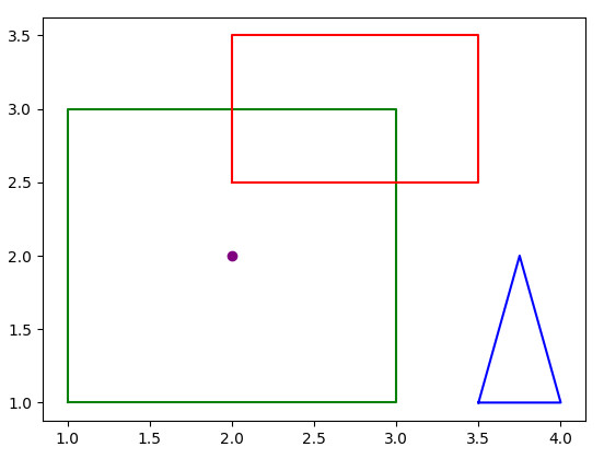
The following examples define one POINT and three POLYGON primitives,
which are shown in the image below:
POINT (2 2)
POLYGON ((1 1, 1 3, 3 3, 3 1, 1 1))
POLYGON ((2 2.5, 2 3.5, 3.5 3.5, 3.5 2.5, 2 2.5))
POLYGON ((3.5 1, 3.75 2, 4 1, 3.5 1))

You can run various types of queries against a geospatial index. For
example, the query below returns one primitive that lies within the boundary
of the green square (from the example above) but omits the square itself:
> FT.SEARCH geomidx "(-@name:(Green Square) @geom:[WITHIN $qshape])" PARAMS 2 qshape "POLYGON ((1 1, 1 3, 3 3, 3 1, 1 1))" RETURN 1 name DIALECT 2
1) (integer) 1
2) "shape:4"
3) 1) "name"
2) "[\"Purple Point\"]"
There are four query operations that you can use with GEOSHAPE fields:
WITHIN: Find points or shapes that lie entirely within an
enclosing shape that you specify in the query.CONTAINS: Find shapes that completely contain the specified point
or shape.INTERSECTS: Find shapes whose boundary overlaps another specified
shape.DISJOINT: Find shapes whose boundary does not overlap another specified
shape.
See
Geospatial queries
for more information about these query types and see
Geospatial indexing
for examples of indexing GEOSHAPE fields.
Limitations of geographical coordinates
Planet Earth is actually shaped more like an
ellipsoid than a perfect sphere.
The spherical coordinate system used by Redis Query Engine is a close
approximation to the shape of the Earth but not exact. For most practical
uses of geospatial queries, the approximation works very well, but you
shouldn't rely on it if you need very precise location data (for example, to track
the GPS locations of boats in an emergency response system).
On this page